Garmin Echomap Plus 43 Clearvu and Traditional Chirp
- Item Number: 010-01885-01
- /
- View More Items by Garmin
- /
- Condition: NEW
| Columbus: | Out of Stock |
| Hebron: | Out of Stock |
| Lebanon: | Out of Stock |
| Obetz: | Out of Stock |
| Springdale: | Out of Stock |
In-store pickup
Product Description
A Great Addition to Any Fishing or Boating Trip
- Bright, sunlight-readable 4.3” combo
- Includes transducer for Garmin CHIRP traditional sonar plus CHIRP ClearVü™ scanning sonar with transom and trolling motor mounts
- Preloaded LakeVü HD maps cover 17,000+ total lakes; 13,000 with 1’ contours
- Built-in Quickdraw Contours mapping software instantly creates personalized fishing maps on-screen with 1’ contours as you fish
- Share waypoints and routes with other ECHOMAP™ or STRIKER™ units
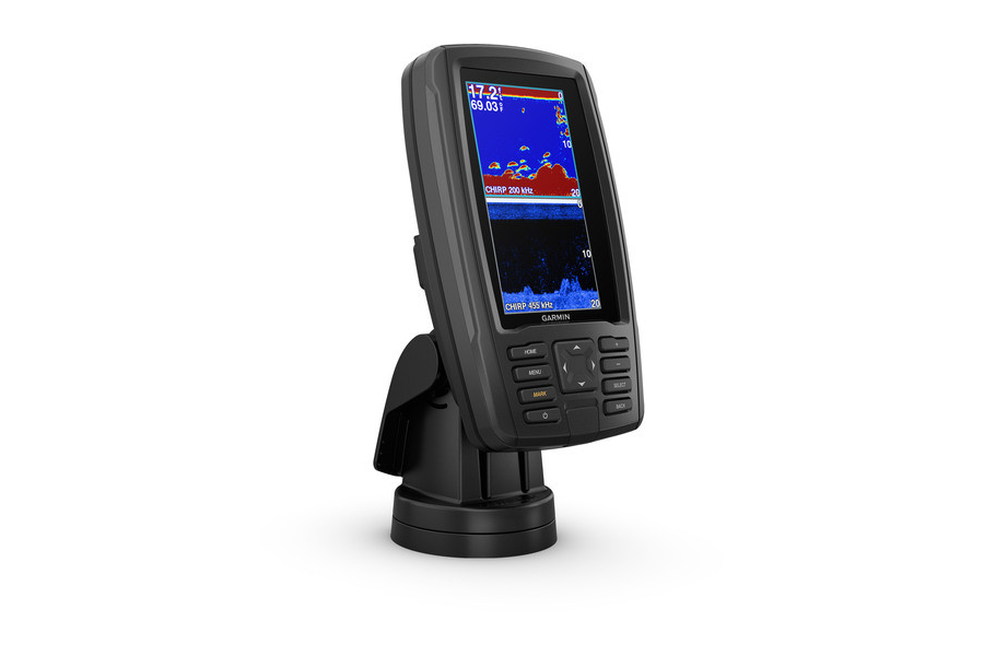
This compact combo has lots of built-in benefits. Easy-to-install and even easier to use, it has a bright screen 4.3” display that is easy to read on a sunny day on the water. It includes one transducer that features both Garmin CHIRP traditional sonar that delivers remarkable target separation and CHIRP ClearVü scanning sonar for nearly photographic images of what’s below the boat. Preloaded with LakeVü HD maps covering 17,000+ total lakes, 13,000 with 1’ contours. Plus, it has Quickdraw Contours mapping software to instantly create personalized fishing maps on-screen with 1’ contours as you fish. You own these maps. They are yours to keep private or share with the Quickdraw Community on Garmin Connect™. Plus, you can share waypoints and routes with other ECHOMAP or STRIKER units. It also features a quick-release mount allowing you to quickly install and remove your device from power and mount. Transom and trolling motor mounts included.
The Garmin CHIRP Difference
The built-in sonar capabilities of ECHOMAP Plus 43cv include our CHIRP traditional sonar, one of the most sophisticated sonar technologies available for the fishing and boating public. CHIRP traditional sonar provides amazingly clear target separation and definition, because it puts even more energy onto the target than traditional sonar. It also provides traditional sonar support for Minn Kota® and MotorGuide® trolling motors with integrated transducers.
Clear Scanning Sonar Images
Garmin CHIRP ClearVü scanning sonar gives you a nearly photographic image of what’s below your boat. You clearly see structure, submerged objects and fish. Garmin CHIRP traditional sonar and CHIRP ClearVü scanning sonar are combined into 1 transducer.
Preloaded LakeVü HD Maps
These highly detailed freshwater maps include more than 17,000 U.S. lakes, rivers and reservoirs. That number also includes more than 13,000 HD lakes with 1’ contours. LakeVü HD gives you excellent detail of underwater features, plus Shallow Water Shading allows you to designate a minimum depth. It also shows interstates, general roads and bridges, designated fishing areas, boat ramps, marinas and campgrounds.
Quickdraw Contours to Create Your Own Maps
Instantly create personalized fishing maps on-screen with 1’ contours as you fish. Tailor them to fit your needs. These are your maps — you own them. Keep the data to yourself, or share it with the Quickdraw Community on Garmin Connect™.
Customer Comments
Customer Reviews
No reviews have been written for this product.
Write a review